


- bhavya gada
- No Comments
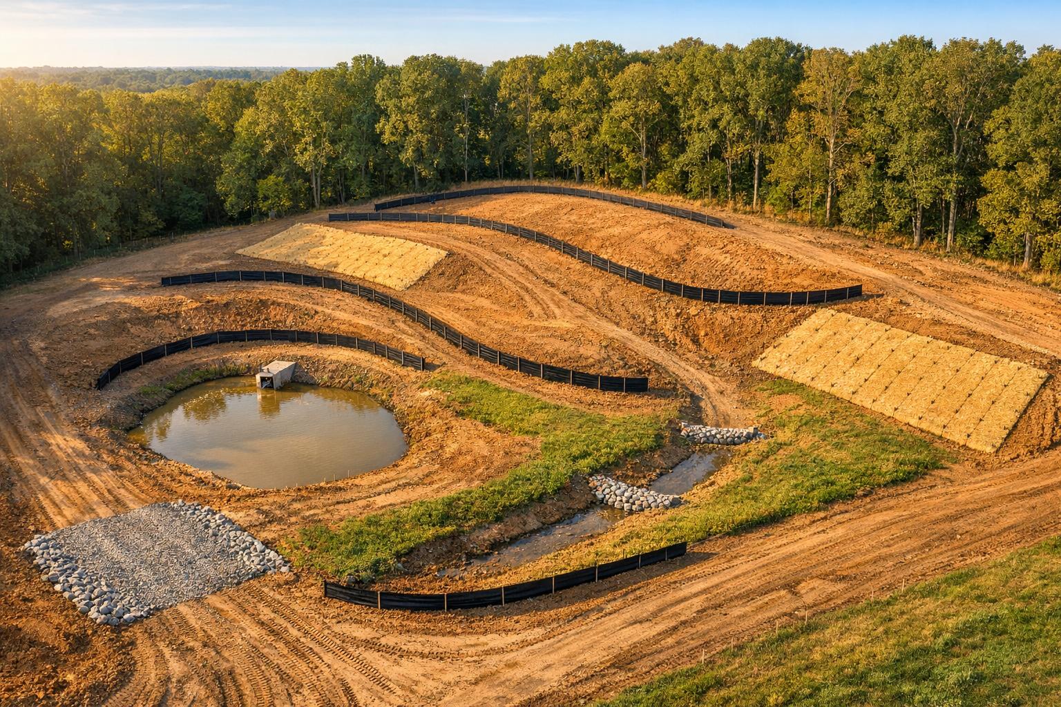
In Maryland, controlling erosion during construction is a legal requirement and a critical step to protect water quality and reduce sediment runoff. Construction sites without proper controls can lose 5–15 tons of soil per acre annually, harming ecosystems like the Chesapeake Bay. This guide outlines how to create an erosion control plan that complies with Maryland regulations and minimizes soil loss.
Key Steps:
- Site Assessment: Identify erosion risks, document sensitive areas, and map stormwater flow.
- Define Disturbance Limits: Mark construction boundaries to minimize soil exposure.
- Grading & Drainage: Plan slopes, drainage zones, and runoff paths to reduce erosion.
- Erosion Controls: Install silt fences, sediment barriers, and stabilization measures like hydroseeding.
- Phased Construction: Limit active work areas and stabilize disturbed zones promptly.
- Plan Approval: Submit detailed documentation and ensure ongoing compliance through inspections.
By following these steps, you can reduce sediment runoff by up to 90%, avoid penalties of up to $10,000 per day, and protect Maryland’s waterways. Proper planning and execution are essential to meet state requirements and maintain site stability.
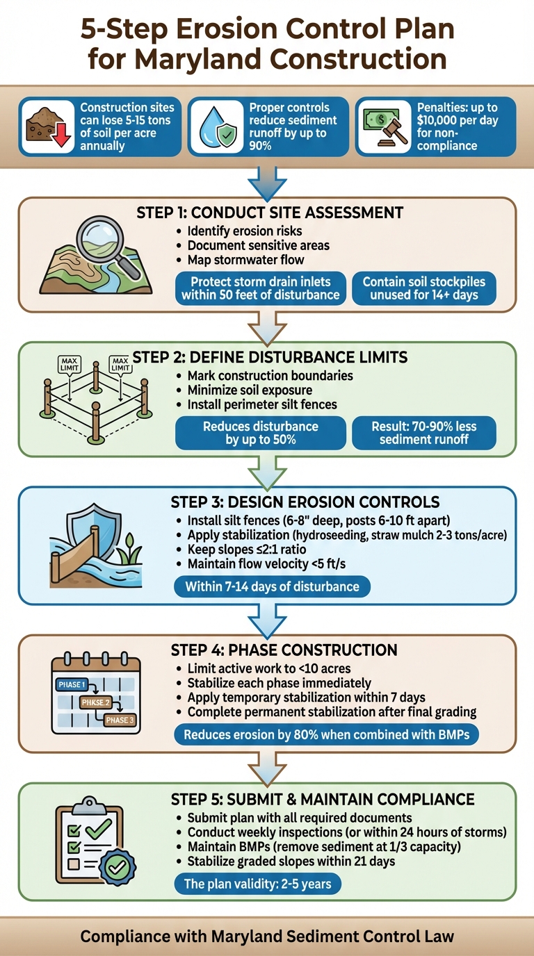
5-Step Erosion Control Plan Process for Maryland Construction Sites
How to Prepare an Erosion and Sediment Control Plan
sbb-itb-843f8be
Step 1: Conduct a Site Assessment
Before starting any construction project, it’s crucial to conduct a detailed site assessment. This step helps you gather essential information, document current conditions, and identify areas prone to erosion. The goal is to understand how water moves across the site, determine which areas are most at risk, and ensure key natural features are protected during construction. This groundwork sets the stage for precise mapping and proper documentation.
Take the time to walk your property under different weather conditions. Pay attention to areas where water pools, steep slopes, and visible signs of erosion. Use photographs to document these key spots for future reference and compliance purposes.
Create Site Maps and Documentation
An effective erosion control plan relies on accurate maps and surveys, especially to meet Maryland’s regulatory standards. Include key elements such as a vicinity map, a property plat outlining legal boundaries, and a topographic survey. Local development service departments often provide standardized worksheets to help identify erosion risks and select the appropriate Best Management Practices (BMPs). For technical guidance, resources like the California Storm Water Quality Association (CASQA) BMP handbooks are invaluable. For example, EC-1 focuses on scheduling strategies, while SE-1 provides specifications for silt fences[6].
Maryland regulations also require that site maps clearly identify all storm drain inlets within 50 feet of soil disturbance areas. These inlets must be properly protected[6]. Additionally, document areas such as concrete washouts, vehicle fueling stations, and soil stockpiles. If soil stockpiles will be left unused for more than 14 days, they must be contained using fiber rolls or gravel bags to prevent erosion[6].
Locate Sensitive Areas on Your Property
Identifying sensitive areas early can save you from potential regulatory issues and costly errors. Look for wetlands, streams, steep slopes (over 15%), and erodible soils that may need vegetative buffers or stabilization. To ensure compliance, consult your local soil conservation district to determine if your property includes jurisdictional wetlands or other protected areas that might require additional permits or safeguards.
Carefully note existing stormwater flow patterns. Mark natural drainage paths, vegetated areas that help stabilize soil, and locations where runoff tends to concentrate before leaving the site. This helps you design erosion control measures that align with the property’s natural water flow, ensuring a more effective and environmentally sound plan.
Step 2: Define Limits of Disturbance and Prepare Site Topography
Once you’ve assessed your site, the next step is to clearly establish the boundaries for construction. Using your site maps and sensitivity analyses, mark the areas where activity will take place. Carefully defined boundaries can cut disturbance by up to 50%, while also ensuring compliance with Maryland’s sediment control regulations[2]. This approach reduces erosion risks and simplifies regulatory adherence.
Mark the Limits of Disturbance
Use durable tools such as silt fencing, flagging tape, stakes, or spray paint to physically mark the construction boundaries outlined in your site maps. Keep clearing to a minimum by avoiding unnecessary disturbances in sensitive areas like steep slopes (greater than 15%), vegetated buffers near waterways, and natural drainage corridors that help stabilize the soil.
Before grading begins, install perimeter controls like silt fences along these boundaries. These measures protect undisturbed vegetation, which serves as a natural barrier against erosion. Sites with well-defined limits and phased grading have been shown to experience 70-90% less sediment runoff during construction[8]. Once the boundaries are set, you can move on to finalizing your grading and drainage plans.
Plan Grading and Drainage
Develop a detailed grading plan that includes final contours, slope grades, and any necessary drainage adjustments. Use topographic data with 1–2 ft intervals to guide your planning. Keep slopes at a maximum of 2:1 (horizontal to vertical) wherever possible, as longer slopes – those exceeding 50 feet – can increase erosion risks by 2 to 3 times compared to shorter ones[2].
Divide the site into drainage zones and map out the paths for runoff. Incorporate features like interceptor swales, berms, or diversions to steer stormwater away from disturbed areas. Ensure flow velocities stay below 5 ft/s to prevent channel scour and sediment movement[2][9]. For projects in central Maryland, Pro Landscapes MD offers specialized services – such as French drains and expert grading – that support erosion control and stormwater management plans throughout Howard County, Montgomery County, and nearby regions.
Step 3: Design Erosion and Sediment Control Measures
Once you’ve established grading and drainage plans, the next step is to implement controls that keep sediment in place. Break the property into drainage areas, map out runoff paths, and select a combination of vegetative, structural, and management solutions[1]. This layered approach tackles erosion from multiple angles.
Install Perimeter Controls
Perimeter controls are your first line of defense, designed to stop sediment from leaving the site and impacting nearby waterways or properties. Silt fences are a common choice and should be installed along downgradient boundaries[1][2]. These temporary barriers, anchored into the ground, filter sediment from runoff. They’re most effective on gentle slopes when paired with proper grading to slow water flow[1].
To install silt fences correctly, dig a trench 6–8 inches deep and 12 inches wide along the perimeter. Lay geotextile fabric with 80% permeability, secure it with posts (spaced 6–10 feet apart and buried 2–3 feet deep), and backfill with compacted soil. Ensure the fabric extends 6 inches above the ground[5][10][8]. For steeper slopes (greater than 2:1) or areas draining more than 1 acre, upgrade to super silt fences reinforced with wire mesh[5][10][8]. In areas with high water velocity or steep terrain, consider alternatives like wattles or rock check dams[5][3][8]. These measures create a solid base for controlling erosion and stabilizing soil quickly.
Apply Stabilization Techniques
Exposed soil is highly vulnerable to erosion, so stabilization needs to happen promptly. Temporary solutions like hydroseeding, straw mulching (2–3 tons per acre), or erosion control blankets can meet Maryland’s guidelines[5][3][7]. Stabilize disturbed areas within 7–14 days of activity. For steep slopes exceeding a 3:1 ratio, use biodegradable mats (such as straw or coconut coir) and secure them with staples every 2–3 feet[3][7][8].
Permanent stabilization takes place after final grading. Roughen the soil surface perpendicular to the slope, add 4–6 inches of topsoil if needed, and seed with approved mixes such as tall fescue at 100–150 pounds per acre[3][7][8]. Cover the area with 2 inches of straw mulch at 80% coverage, and water lightly to encourage germination without causing runoff[3][7][8]. Long-term erosion control relies on established vegetation[11]. Sodding is ideal for high-traffic zones, while native grasses with deep roots provide lasting stability. For specialized drainage and grading services in central Maryland, Pro Landscapes MD offers French drain installations and professional land leveling, supporting erosion control plans across Howard and Montgomery Counties.
Sequence Controls by Construction Phase
Proper sequencing of controls is essential to reduce the amount of exposed soil. Start by installing perimeter silt fences and inlet protections before clearing, then limit clearing and grading to only the areas currently needed. Stabilize disturbed zones immediately after work in those areas[5][2][11]. This phased approach keeps soil exposure to a minimum and helps meet regulatory standards[5][4][8]. Limit active work to less than 10 acres at a time, stabilizing each phase as it wraps up[5][4][8]. Include a detailed phasing schedule with clear timelines, and inspect all controls weekly or after rainfall exceeding 0.5 inches to ensure compliance[3][7].
Step 4: Develop a Construction Phasing and Stabilization Sequence
Once you’ve completed your site assessment, defined the disturbance limits, and installed erosion controls, it’s time to create a phased construction plan. Breaking the project into phases helps keep soil exposure to a minimum, significantly reducing erosion risks – by as much as 80% when combined with effective Best Management Practices (BMPs) [5]. Your plan should include a detailed schedule outlining areas of disturbance, stabilization timelines, and maintenance duties [1]. This ensures a seamless transition from planning to execution, building on your earlier assessments and control measures.
Follow the Standard Construction Sequence
Start by installing key protective measures like silt fences, sediment barriers, inlet protections, and storm drain guards before any clearing or grading begins. Set up diversions to redirect water away from areas that will be disturbed. Then, move forward with phased clearing and rough grading, ensuring each completed section is stabilized immediately [2]. For activities like stream crossings, schedule them during dry periods and have all necessary materials ready on-site. Water diversion may also be necessary. To maintain control, limit active work areas to 10–25 acres at a time, adjusting based on site-specific conditions and weather [5].
Temporary vs. Permanent Stabilization
Temporary stabilization measures, such as hydroseeding, straw mulch, or erosion control blankets, should be applied within 7 days of inactivity, with full stabilization achieved within 14 days of disturbance [3]. For example, mulch alone can reduce runoff velocity by 50–75% [5]. Once final grading is complete, switch to permanent stabilization methods. Options include sodding for high-traffic zones, deep-rooted seeding for slopes steeper than 3:1, and riprap for channels. Ensure permanent vegetation is fully established before closing out the project. Regular inspections – every 7 days or within 24 hours of a storm – are essential to confirm the effectiveness of these measures [3].
Step 5: Submit the Plan for Approval and Maintain Compliance
With your phased construction and stabilization sequence ready, the next step is to secure formal approval before breaking ground. This process ensures your plan aligns with Maryland’s regulatory standards and establishes a framework for staying compliant during construction.
Prepare Plan Submission Documents
To submit your plan, you’ll need to compile a detailed package of documents. Start with a transmittal letter that includes the project name, location, key stakeholder contacts, a brief description of the project, and a reference to Maryland’s Sediment Control Law. Make sure to include contact details for all key stakeholders.
Your package should also outline Best Management Practices (BMPs) responsibilities, stabilization timelines, and inspection protocols. These details will help streamline the review process and guide site management during construction.
Additionally, include site maps showing disturbance limits and BMP locations, a grading plan, the construction phasing sequence, and the necessary certification statements. This thorough documentation reinforces the erosion control measures you’ve planned and sets a clear path for compliance. Keep in mind that approved plans are typically valid for 2 to 5 years. After this period, you’ll need to either renew or update the plan to reflect any changes in site conditions or regulations.
Before submitting the plan, schedule a preconstruction meeting with all relevant parties, including the owner, contractor, and erosion control inspector. This meeting is essential for reviewing the approved plan, construction sequence, maintenance responsibilities, and inspection protocols – especially for complex projects. Once approved, the plan becomes part of your general construction contract, detailing BMP locations, design specs, installation steps, and timelines.
Ensure Ongoing Compliance
After construction begins, regular inspections are critical to maintaining compliance. During these inspections, verify that BMPs are functioning as intended. For example, check that silt fences haven’t exceeded one-third of their capacity, confirm disturbed areas are stabilized, and evaluate sediment traps and drainage systems. Document your findings with photos and logs for accountability.
Maintenance is key to staying compliant. This includes tasks like removing sediment from traps and fences when they reach one-third capacity, repairing damaged BMPs immediately, and maintaining construction entrances with proper rock stabilization. If inspections uncover issues – such as failed BMPs or unexpected sediment discharge – act quickly to correct the problem. Document all actions taken and notify the appropriate authorities if required. For serious issues, you may need to pause construction until the problem is resolved.
To avoid setbacks, assign a dedicated site foreman and ensure your crew is trained in BMP maintenance. Proactive management can help prevent problems before they escalate. Regular upkeep and quick responses to issues will keep your project on track and in compliance with regulations.
How Pro Landscapes MD Supports Erosion Control Plan Implementation

Turning a well-thought-out erosion control plan into real-world results requires skilled execution. That’s where Pro Landscapes MD steps in, delivering expert services to ensure plans are effectively brought to life on-site.
Implementing erosion control measures involves deep knowledge of stormwater management, grading, and drainage systems. Pro Landscapes MD offers these services across central Maryland, helping homeowners and contractors tackle runoff and stabilize soil during construction projects.
Custom Solutions for Central Maryland’s Landscape
The terrain in central Maryland comes with its own set of challenges. From the steep slopes in areas like Clarksville and Potomac to the heavy stormwater runoff in Ellicott City and Gaithersburg, every property is unique. Pro Landscapes MD tailors solutions to fit these natural features. They aim to preserve existing vegetation buffers when possible and incorporate features like retaining walls, garden walls, and environmental pavers to stabilize slopes. This approach not only minimizes erosion but also enhances the visual appeal of the property. It’s a smart combination of functionality and aesthetics, ensuring compliance while promoting long-term landscape health.
Drainage and Grading Expertise
Proper drainage is a cornerstone of any erosion control strategy. Pro Landscapes MD specializes in installing French drains, which channel excess water away from critical areas, reducing the risk of soil saturation and slope failure. They also design dry riverbeds, which are rock-lined channels that mimic natural waterways, to manage stormwater runoff during heavy rains. These features are often paired with regrading to ensure water flows away from disturbed areas, protecting the soil and preventing sediment runoff.
Their regrading services further enhance natural drainage patterns, reducing exposed soil and supporting the site’s overall stability. This aligns with the early stages of your erosion control plan, where defining disturbance limits and stabilizing slopes are critical. By integrating drainage systems like French drains early in the construction process – installing perimeter controls and diversions before grading begins – they adhere to Maryland’s best practices for sediment management during phased development. This seamless integration ensures that every part of your erosion control strategy works together for maximum effectiveness.
Conclusion
An erosion control plan plays a key role in safeguarding water quality, ensuring property stability, and stopping sediment runoff. As the North Carolina Department of Environmental Quality emphasizes, "The plan should serve as a blueprint for the location, installation, and maintenance of practices to control all anticipated erosion and prevent sediment from leaving the site." [2]
By following a five-step process, you can avoid the high costs of repairing erosion damage by addressing sediment control from the beginning. As DigCastle points out, "Repairing erosion damage is more expensive than preventing it." [12] This structured approach also ensures you’re prepared to seek expert help if needed.
Regulations call for stabilizing graded slopes within 21 days and require inspections at least once every seven days to maintain protection measures [2][12][13].
For projects requiring precision and compliance with Maryland’s specific regulations, professional support can make the process easier. Pro Landscapes MD specializes in stormwater management and grading, helping homeowners and contractors in central Maryland turn erosion control plans into practical, effective solutions.
FAQs
Do I need an erosion control plan for my project in Maryland?
Yes, in Maryland, you’re required to have an erosion control plan if your project disturbs 5,000 square feet of land or involves moving 100 cubic yards of soil. This plan must be reviewed and approved before any construction work starts.
What BMPs work best for steep slopes and heavy runoff?
Managing steep slopes and handling heavy runoff requires a thoughtful approach using Best Management Practices (BMPs). Some of the most effective strategies include:
- Retaining walls: These structures help keep soil in place, preventing it from sliding or eroding.
- Terraced slopes: By creating step-like levels, terraces slow down the flow of water, reducing its erosive power.
- Vegetative stabilization: Planting native vegetation is a natural way to secure soil, as roots help anchor it in place.
In addition to these methods, proper grading and drainage planning play a key role. These measures ensure water flows away in a controlled manner, minimizing the risk of erosion and excessive runoff on steep terrain.
What documents are required to get an erosion control plan approved?
In Maryland, getting approval for an erosion control plan involves submitting several key documents. These include site maps that detail drainage and vegetation, grading and drainage plans, and a list of erosion control measures like silt fences. You’ll also need to provide a vegetative stabilization plan, a construction schedule, and any required permits.
For larger sites, you might also have to include a Stormwater Pollution Prevention Plan (SWPPP). Additionally, the process requires regular inspections and maintaining proper compliance documentation.
Chat with Us