









- bhavya gada
- No Comments
- Purpose: Prevent soil erosion and manage runoff to protect waterways like the Chesapeake Bay.
- Requirements: Include project details, site data (e.g., contours, drainage), and certifications from licensed professionals.
- Key Steps: Map site conditions, document sensitive areas (wetlands, slopes), and design effective erosion controls.
- Approval Timeline: Reviews by local Soil Conservation Districts can take up to 6 months.
Pro Tip: Work with experts who know Maryland’s regulations to avoid delays and ensure compliance.
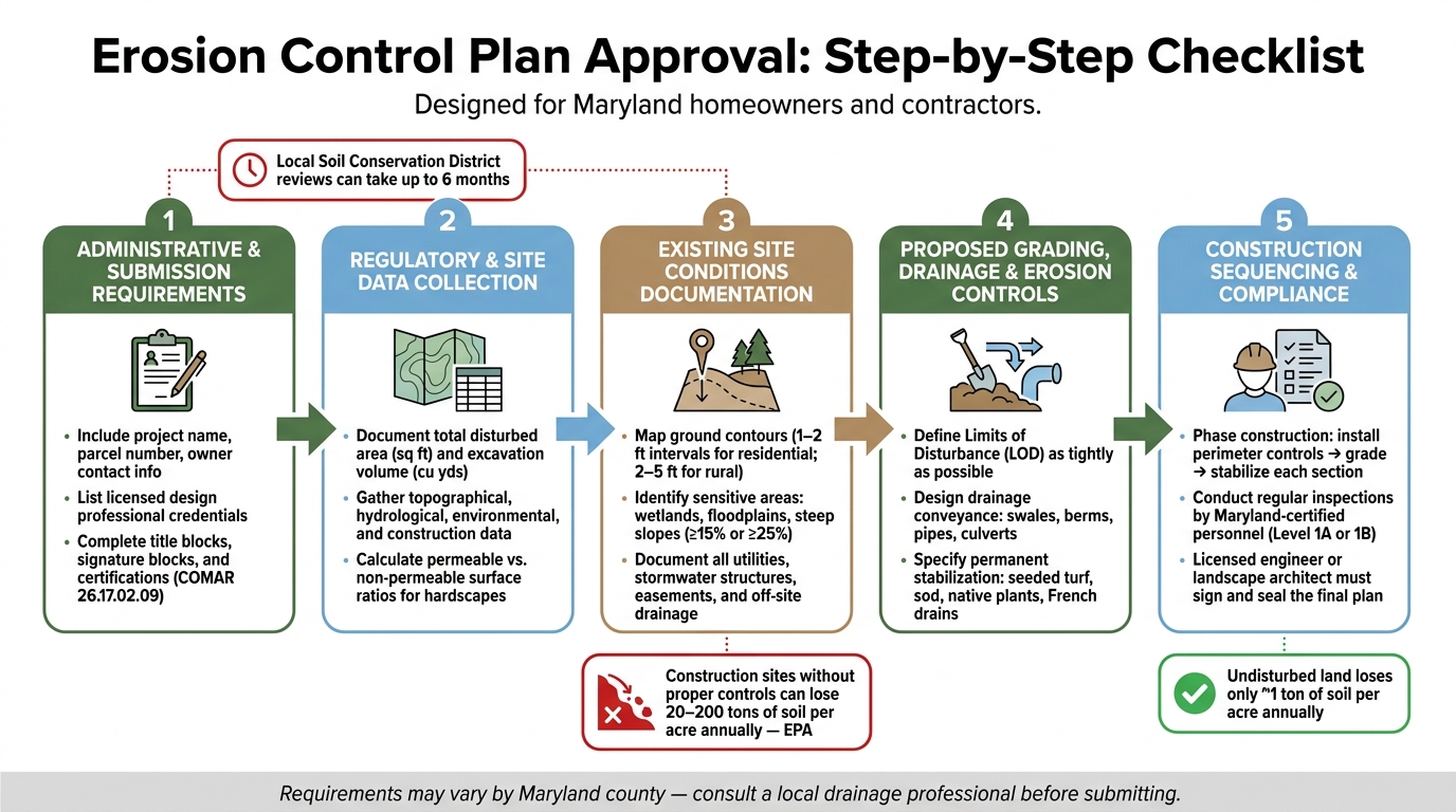
Erosion Control Plan Approval: Step-by-Step Checklist
How to Prepare an Erosion and Sediment Control Plan
sbb-itb-843f8be
Administrative and Submission Requirements
Double-check that all administrative details are complete before submitting your plans. Missing signatures or incorrect addresses can lead to delays or even require you to resubmit.
Project Information and Ownership Details
Make sure to include all key project details, such as the project name, site address, tax parcel number, and the property owner’s full legal name and contact information. If a licensed design professional, like an engineer or landscape architect, is involved, their firm’s details (phone number, address, and license number) should also be listed. If a contractor is part of the project, their contact information must be included as well. This ensures reviewers can easily contact the responsible parties.
Plans should be tailored to the specific property, taking into account existing water flow, grading challenges, and any areas where water tends to pool [1]. Additionally, remember to complete the title and approval blocks as required.
Approval Blocks and Certifications
Each sheet of your plan must include a consistent title block. This should feature the project name, sheet title, sheet number, scale, north arrow, preparation date, and a revision history. Signature and approval blocks are equally critical. Maryland-specific plans, as governed by COMAR 26.17.02.09, require designated spaces for signatures and dates from the reviewing engineer or Soil Conservation District representative [4].
The design professional responsible for the plan must also include a certification statement. This statement confirms that the plan adheres to Maryland’s erosion and sediment control standards.
Regulatory and Site Data
After completing the administrative section, gather all necessary regulatory and site data to support your plan. This includes documenting the total disturbed area (in square feet) and the total excavation volume (in cubic yards).
Key data categories to include:
| Data Category | Required Documentation |
|---|---|
| Topographical Data | Property layout, slope percentages, and custom grading plan [1] |
| Hydrological Data | Runoff patterns, pooling areas, and drainage complexity [1] |
| Environmental Data | Soil types, plant selections suited to the climate, and natural filtration zones [2] |
| Construction Data | Excavation limits, base material specifications, and stabilization methods [3] |
For projects involving hardscapes, like paver driveways or patios, you’ll also need to document the ratio of permeable vs. non-permeable surfaces. This is essential for stormwater runoff calculations [3]. Keep in mind that specific requirements may vary by county. It’s a good idea to consult with a drainage professional familiar with your Maryland jurisdiction before submitting your plan [1].
Existing Site Conditions
Establishing a clear baseline of current site conditions is crucial to avoid delays in project approvals caused by incomplete or inaccurate documentation.
Topographical and Drainage Mapping
Your base map should include ground contours at 1- to 2-foot intervals for residential and small commercial sites, or 2- to 5-foot intervals for larger, rural properties. Be sure to include a labeled benchmark with an elevation reference, such as NAVD88. Beyond just contours, the map must feature flow arrows that indicate the direction of overland drainage across slopes, swales, and ditches. Clearly label low and high points on the map.
It’s also important to show off-site drainage flows, such as those from neighboring lots, using dashed features and directional arrows. Ignoring these off-site contributing areas is a common mistake that can lead to erosion control failures. According to the EPA, construction sites without proper controls can lose 20 to 200 tons of soil per acre annually. Undersized sediment traps, often caused by underestimating contributing drainage areas by just 20–30%, are a leading cause of sediment discharge and enforcement actions.
After addressing contours and drainage, move on to documenting natural resources and sensitive areas for a more complete picture of site conditions.
Natural Resources and Sensitive Areas
All regulated or sensitive features on or near the site must be identified and labeled. These include perennial and intermittent streams (with centerlines and top-of-bank), delineated wetlands, FEMA-mapped 100-year floodplains and floodways, and riparian buffers with their required setbacks. Steep slopes – typically defined as ≥15% or ≥25% by local codes – should be shaded or outlined, with labels for both the slopes and any erodible soils identified by the NRCS.
While desktop GIS layers and FEMA maps are helpful starting points, field verification is essential. A site visit can uncover details like blocked culverts, active erosion (rills or gullies), or informal drainage paths that aren’t visible on maps. Photographs from key vantage points, complete with location and directional notes, can support design decisions and help expedite the review process. If wetlands are suspected, a qualified wetland professional should confirm boundaries before finalizing plans.
Once natural features are documented, the next step is to catalog existing infrastructure to ensure compatibility with proposed erosion controls.
Existing Infrastructure and Utilities
The existing-conditions sheet must include all underground and overhead utilities – electric, gas, water, sewer, telecom, and fiber lines – as well as features like manholes, hydrants, and utility boxes. Additionally, existing stormwater structures such as inlets, storm pipes (labeled with size and material, e.g., "15" RCP"), culverts, swales, ditches, and outfalls must be shown. Include pipe inverts and slopes wherever possible to ensure that proposed erosion controls align seamlessly with current infrastructure.
Easements – whether for drainage, utilities, access, or conservation – must be clearly marked and labeled with their purpose. Placing sediment basins or diversion dikes over water lines or within restricted easements can lead to costly redesigns during construction. Add a note reminding contractors to call 811 before any excavation begins. For projects in central Maryland, working with contractors experienced in drainage systems and stormwater management – such as Pro Landscapes MD – can help identify real-world drainage patterns and potential conflicts with infrastructure before they become costly issues.
Proposed Grading, Drainage, and Erosion Controls
Turning site conditions into a detailed and effective design requires careful planning. This section focuses on three key elements of erosion control plans: setting clear work boundaries, managing water flow, and implementing soil stabilization techniques.
Limits of Disturbance and Clearing Areas
The limits of disturbance (LOD) mark the boundary where grading, clearing, or construction activities must stop. Keeping the LOD as tight as possible reduces the area that needs erosion controls and helps control sediment runoff. It’s crucial to clearly show the LOD on the plans to ensure compliance and minimize unnecessary disturbance.
Once boundaries are defined, the next step is designing drainage systems that manage runoff effectively.
Drainage Patterns and Conveyance Systems
Grading should guide water toward stable discharge points. For example, sloping the ground away from structures helps protect foundations from water infiltration. Including detailed drainage features in the plans shows how stormwater will be managed. In cases where vegetated channels can’t handle concentrated runoff, systems like pipes or box culverts may be necessary. Berms and swales can also work together – berms direct sheet flow, while swales capture and slow runoff, allowing groundwater to recharge naturally.
Erosion Control Measures and Stabilization
Every erosion control measure should be clearly identified and aligned with standard engineering practices or state guidelines. For permanent stabilization, the plan must specify the final ground cover for all disturbed areas, whether that’s seeded turf, sod, native plants, or another approved material. Vegetated swales, for instance, should include native, water-tolerant plants to help anchor the soil and filter runoff effectively. In areas prone to high water tables or near building foundations, French drains can be a smart addition. These systems use perforated pipes surrounded by crushed stone to channel water away from sensitive areas.
If you’re tackling a complex grading or drainage project in central Maryland, Pro Landscapes MD provides expert services, including grading, French drain installation, and stormwater management, all designed to meet regional standards.
Construction Sequencing and Compliance
Proper sequencing in construction helps limit exposed bare soil, reducing sediment runoff while staying within regulatory guidelines.
Phased Construction and Stabilization
Limit soil disturbance by breaking the work into manageable phases. Instead of clearing and grading the entire site at once, tackle one section at a time. Start by installing perimeter controls, then move on to clearing and grading a specific area. Stabilize each section before advancing to the next. Your approved erosion and sediment (E&S) plan will outline the required sequence of operations, which typically includes steps like clearing, rough grading, installing structural controls, fine grading, and final stabilization. Strictly following these steps is mandatory for compliance. Apply temporary measures like seeding, mulching, or sod immediately after grading, based on local standards.
This phased method ensures sediment controls are effective throughout all stages of the project, aligning with earlier planning efforts.
Inspection and Maintenance Requirements
Defining construction phases is just the start – ongoing inspections are critical to maintaining compliance.
Erosion control measures need consistent monitoring to ensure they work as intended. Regular inspections, often required after heavy rainfall or at scheduled intervals, are essential. In Maryland, these inspections must be carried out by certified personnel. The state’s certification system includes various levels, such as Level 1A (Field Maintenance) and Level 1B (Inspector), ensuring inspectors are qualified to assess features like silt fences, sediment basins, and stabilized areas. Any problems identified during inspections should be addressed promptly, following severity-based guidelines.
Plan Certification and Monitoring Notes
After sequencing and inspections, proper documentation and certification are key to compliance.
A licensed Maryland engineer or landscape architect must sign and seal the plan [1]. For projects involving significant vegetation or restoration work, additional sign-offs may be required from a licensed Maryland forester or a horticulturist with a college degree [6]. The approved plan should include detailed monitoring notes that outline responsibilities, such as who conducts inspections, how findings are recorded, and when a plan revision might be necessary. Keeping a standardized inspection log is vital for demonstrating compliance during audits [5].
Conclusion
Key Takeaways
Getting an erosion control plan approved boils down to three essentials: accurate paperwork, tailored design, and disciplined construction practices.
First, double-check every administrative detail – ownership info, parcel numbers, and certifications must align perfectly across all forms. Reviewers are quick to spot inconsistencies, and even a minor mismatch can send your plan back for revisions. Next, let the site itself guide your design. Features like steep slopes, erodible soils, or proximity to sensitive areas like wetlands demand stronger control measures. Ignoring these factors often leads to plan rejections and delays.
But approval isn’t the finish line. Compliance requires immediate action: install perimeter controls right away, stabilize disturbed areas quickly, and keep meticulous inspection records. The EPA highlights the stakes – active construction sites without proper controls can lose 100–200 tons of soil per acre annually, compared to just 1 ton per acre on undisturbed land. A solid plan, well-executed, can drastically reduce this erosion.
How Pro Landscapes MD Simplifies the Process

Tackling these challenges can feel overwhelming, but expert help can make all the difference. For Maryland homeowners managing grading, drainage, or landscaping projects, navigating the approval process often means dealing with multiple county agencies. That’s where Pro Landscapes MD shines. They’re experienced with local requirements across Howard, Montgomery, Carroll, Frederick, Prince George’s, and Baltimore counties, so they know exactly what reviewers look for – and the common pitfalls to avoid.
From the initial site assessment – evaluating drainage, slopes, and sensitive areas – to crafting plans that combine erosion controls with long-term landscaping solutions like retaining walls or French drains, their team handles it all. Plus, they offer free site visits and proposals, giving you clarity before you commit. For projects involving challenging terrain, drainage issues, or sensitive locations near wetlands, partnering with professionals like Pro Landscapes MD can speed up approvals and help sidestep costly surprises during construction.
FAQs
What causes an erosion control plan to be rejected?
Erosion control plans often face rejection when they don’t align with local runoff regulations or fail to incorporate a customized strategy for managing water flow. Common pitfalls include poor grading techniques, neglecting specific soil conditions, or omitting essential drainage features such as berms, swales, or pipes. Pro Landscapes MD specializes in conducting thorough site assessments and creating designs that meet water quality and erosion control standards, helping clients secure regulatory approval.
Do I need a licensed engineer or landscape architect to sign the plan?
In Maryland, whether your erosion control plan requires a licensed engineer or landscape architect’s signature depends on local regulations. While Pro Landscapes MD provides expert design and drainage solutions, it’s essential to consult your local permitting office. They can clarify if your project needs a formal seal from a licensed professional to meet regulatory requirements.
How can I speed up erosion control plan approval in Maryland?
To get your erosion control plan approved faster in Maryland, focus on creating a detailed and precise plan that aligns with all regulatory requirements. Include comprehensive site maps, clear strategies to limit land disturbance, and methods to safeguard natural resources. Make sure your project meets the necessary permit thresholds, such as disturbing 5,000 square feet of land or moving 100 cubic yards of soil. Submitting all required documentation early and collaborating with local agencies can also help speed up the review process.
Chat with Us