


- bhavya gada
- No Comments
Hydrological modeling is essential for managing Maryland’s stormwater challenges, driven by varied soil types, frequent heavy storms, and strict regulations. The right tools help predict water flow, design effective drainage solutions, and comply with Maryland Department of the Environment (MDE) requirements. Here’s what you need to know:
- Key Challenges: Maryland’s diverse soils (from sandy to clay-heavy) and storm patterns (intense thunderstorms and multi-day events) demand precise runoff and infiltration modeling.
- Regulatory Goals: Models must address water quality, channel protection, and flood control for events ranging from 1-year to 100-year storms.
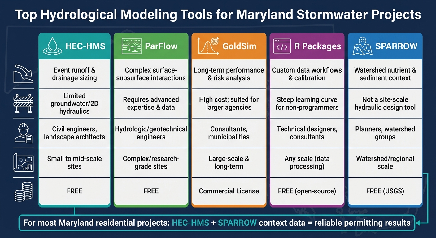
- Top Tools: The best tools include HEC-HMS for runoff analysis, ParFlow for groundwater flow, GoldSim for long-term performance, R hydrology packages for custom workflows, and SPARROW for watershed-scale insights.
Quick Comparison:
| Tool | Best For | Key Limitation | Cost |
|---|---|---|---|
| HEC-HMS | Event runoff, drainage sizing, permitting | Limited groundwater/2D hydraulics | Free |
| ParFlow | Complex surface-subsurface interactions | Requires advanced expertise | Free |
| GoldSim | Long-term performance/risk analysis | High cost, large-scale focus | Commercial |
| R Packages | Custom workflows, data analysis | Steep learning curve for beginners | Free |
| SPARROW | Watershed nutrient/sediment context | Not for site-scale hydraulic design | Free (USGS) |
Each tool serves specific project needs, from small residential drainage fixes to large-scale watershed planning. For most residential projects, HEC-HMS paired with local data (e.g., NOAA Atlas 14 and NRCS soil groups) offers reliable results, while advanced tools like ParFlow and GoldSim are better suited for complex or large-scale projects.
Top Hydrological Modeling Tools for Maryland Stormwater Projects
Key Factors for Hydrological Modeling in Maryland
Maryland-Specific Hydrological Data
The accuracy of any hydrological model starts with the quality of its input data. In Maryland, that means relying on local data rather than generic national datasets or values borrowed from neighboring states.
One of the most important inputs is the rainfall intensity–duration–frequency (IDF) curves from NOAA Atlas 14. These curves help define the expected intensity of a storm based on its duration and return period – for example, comparing a 1-hour, 10-year storm in Baltimore to one in Annapolis. Pair this with NRCS soil group data to better understand runoff potential and infiltration rates.
Maryland’s soil conditions can vary significantly, even over short distances. For instance, a suburban lot in Howard County with Group B soils might support features like rain gardens or infiltration trenches effectively. But a similar lot in Baltimore County, where Group C or D soils dominate, could require solutions like underdrains, amended soil media, or larger storage volumes to achieve the same results. Misjudging soil group classifications can lead to inaccurate runoff calculations, improper sizing, and flawed drawdown estimates. To round out the data, land use and topographic information – often sourced from Maryland iMAP and county LiDAR datasets – are essential for capturing site-specific conditions like development patterns and vegetation.
Maryland Stormwater Regulatory Requirements
Stormwater regulations in Maryland are not a single set of rules but a layered system of performance goals that hydrological models must address simultaneously. These goals are summarized in the table below:
| Regulatory Goal | Design Storm | What the Model Must Show |
|---|---|---|
| Water Quality Volume (WQv) | ~1-inch storm | Volume captured and treated by ESD practices |
| Channel Protection (Cpv) | 1- to 2-year event | Extended detention to limit erosive flows |
| Overbank/Flood Control | 10- and 100-year events | Peak flow attenuation and safe conveyance |
Maryland’s Environmental Site Design (ESD) policy emphasizes small, distributed stormwater practices rather than large, centralized detention ponds. As a result, hydrological models must account for multiple Best Management Practices (BMPs) such as bioretention cells, permeable pavers, and swales. Each of these has unique storage, infiltration, and outlet characteristics. A tool that only models a single detention basin won’t meet the needs of most Maryland projects.
Typically, practitioners run separate simulations for each regulatory scenario and compare pre- and post-development hydrographs to demonstrate compliance. These regulatory goals directly influence the design and placement of BMPs, ensuring that the modeling results align with the physical layout of the site.
Connecting Hydrological Modeling to Landscaping and Hardscaping
Once accurate local data is applied and regulatory targets are clear, hydrological modeling becomes a practical tool for guiding on-site design. The outputs from these models – such as flow concentration points, movement speeds, and volume management needs – inform key decisions about grading, drainage, and hardscaping.
For instance, if a model predicts that runoff from a proposed patio will flow toward a building’s foundation, solutions might include regrading the lawn, installing a French drain along the patio’s edge, or adding a dry riverbed to redirect the flow to a lower area. These kinds of adjustments ensure that modeled flow paths translate into effective site work.
"Drainage problems are complex and require a custom approach for each project." – Pro Landscapes MD [1]
This is where the connection between modeling and physical design becomes critical. Companies like Pro Landscapes MD specialize in implementing solutions such as French drains, dry riverbeds, grading, and stormwater management systems across central Maryland. By using hydrological models to size and locate these features, they can address drainage challenges effectively before construction even begins.
sbb-itb-843f8be
How to Evaluate Hydrological Modeling Tools
Tool Evaluation Criteria
Not all hydrological tools are suitable for Maryland stormwater projects. The choice depends heavily on the project’s specific needs and what the reviewing authority will approve.
- NRCS CN Method Support: Ensure the tool supports the NRCS Curve Number (CN) method, as Maryland relies on TR-55 for runoff estimation. It should handle calculations for impervious surfaces, detention sizing, infiltration estimates, and peak flow comparisons. These outputs are essential for most Maryland permit submissions.
- GIS Compatibility: This feature is almost essential for Maryland projects. Tools that can directly import shapefiles or DEMs make use of Maryland’s extensive spatial data, minimizing manual errors and aligning with local practices for mapping drainage areas or analyzing pre- and post-development conditions.
- Ease of Use at Scale: Simplicity often matters more for smaller projects, such as backyard drainage fixes or rain garden retrofits. The tool’s complexity should match the scale of the project. For smaller sites, user-friendly tools can save time and effort without sacrificing accuracy.
To make the selection process easier, a side-by-side comparison framework can help identify the best tool for any given project scale.
Building a Comparison Framework
Maryland’s strict stormwater standards make it crucial to compare tools based on how well they meet local requirements. The table below breaks down key criteria by project size:
| Criterion | Small Residential Sites (< 5 acres) | Subdivision / Mid-Scale (10–100 acres) | Watershed / MS4 Planning |
|---|---|---|---|
| NRCS CN Method Support | Essential | Essential | Preferred |
| GIS Integration | Helpful | Important | Essential |
| Green Infrastructure / ESD Modules | Essential | Essential | Important |
| Probabilistic / Scenario Analysis | Not needed | Optional | Recommended |
| Learning Curve | Low preferred | Moderate acceptable | High acceptable |
| Regulatory Output / Report Export | Essential | Essential | Essential |
The table highlights a simple rule: match the tool’s complexity to the project’s scale and audience. For instance, a landscape designer working on a French drain installation doesn’t need the same tool as a consultant modeling a county-wide MS4 retrofit. Using a tool that’s too complex for small jobs wastes time, while an overly simplistic tool for larger, regulated projects could lead to issues during reviews.
Before committing to a tool, confirm it’s accepted – or at least not dismissed – by the relevant reviewing authority. Maryland Department of the Environment (MDE), local stormwater programs, and Chesapeake Bay Program guidance often have preferences. Even a technically sound tool can cause delays if its output format isn’t familiar to reviewers.
Hydrological Modelling in HEC-HMS 4.11: Tutorial for Beginners
Top Hydrological Modeling Tools for Maryland
Maryland’s stormwater projects vary widely – from small backyard drainage solutions to large-scale subdivision retrofits. With such diversity, no single tool can address every scenario. However, the following five tools are particularly suited for tackling Maryland’s stormwater challenges.
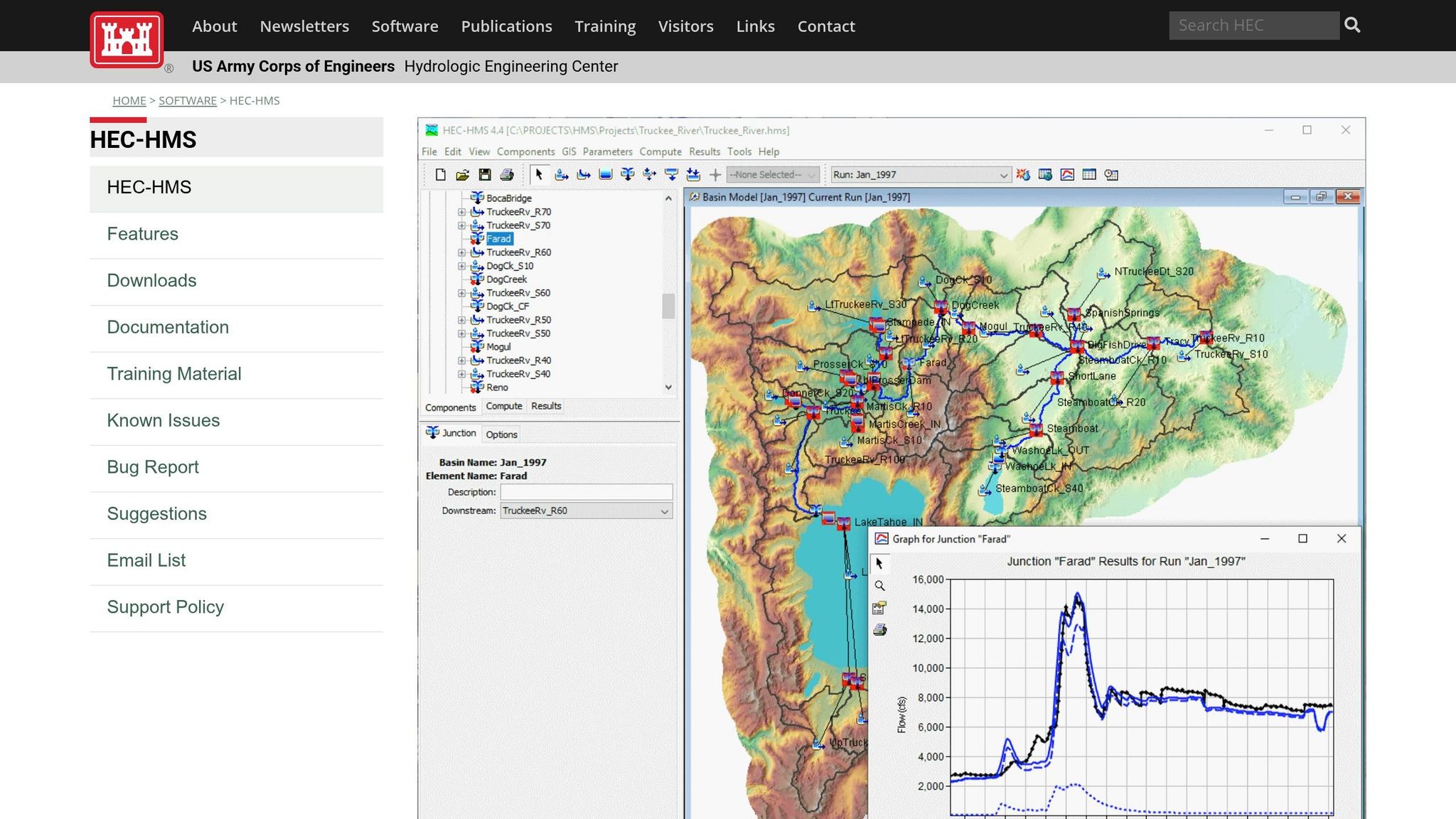
HEC-HMS: Basin and Flow Analysis
The Hydrologic Engineering Center – Hydrologic Modeling System (HEC-HMS) is a go-to tool for stormwater modeling in Maryland. Developed by the U.S. Army Corps of Engineers, it’s free and simulates the entire precipitation-runoff process, covering everything from canopy interception to channel routing.
HEC-HMS integrates the NRCS Curve Number (CN) method, aligning with Maryland Department of the Environment (MDE) standards. This allows users to assign CN values for various land covers – like woods, lawns, or impervious surfaces – based on Maryland’s unique Piedmont and Coastal Plain soils. Designers can model multi-stage outlet structures (orifices, weirs, risers) to ensure detention ponds meet peak-flow reduction targets for 1-, 10-, and 100-year storm events, as required for permits.
For instance, a consultant working on a 20–50 acre residential drainage area can use HEC-HMS to compare pre- and post-development hydrographs. By adjusting the stage–storage–discharge relationship, they can meet local criteria for drawdown times and peak flow rates. While HEC-HMS is a solid foundation for stormwater analysis, it’s less equipped to handle detailed groundwater flow or 2D overland hydraulics, which are important for complex sites like those with karst topography.
ParFlow: Surface and Subsurface Modeling
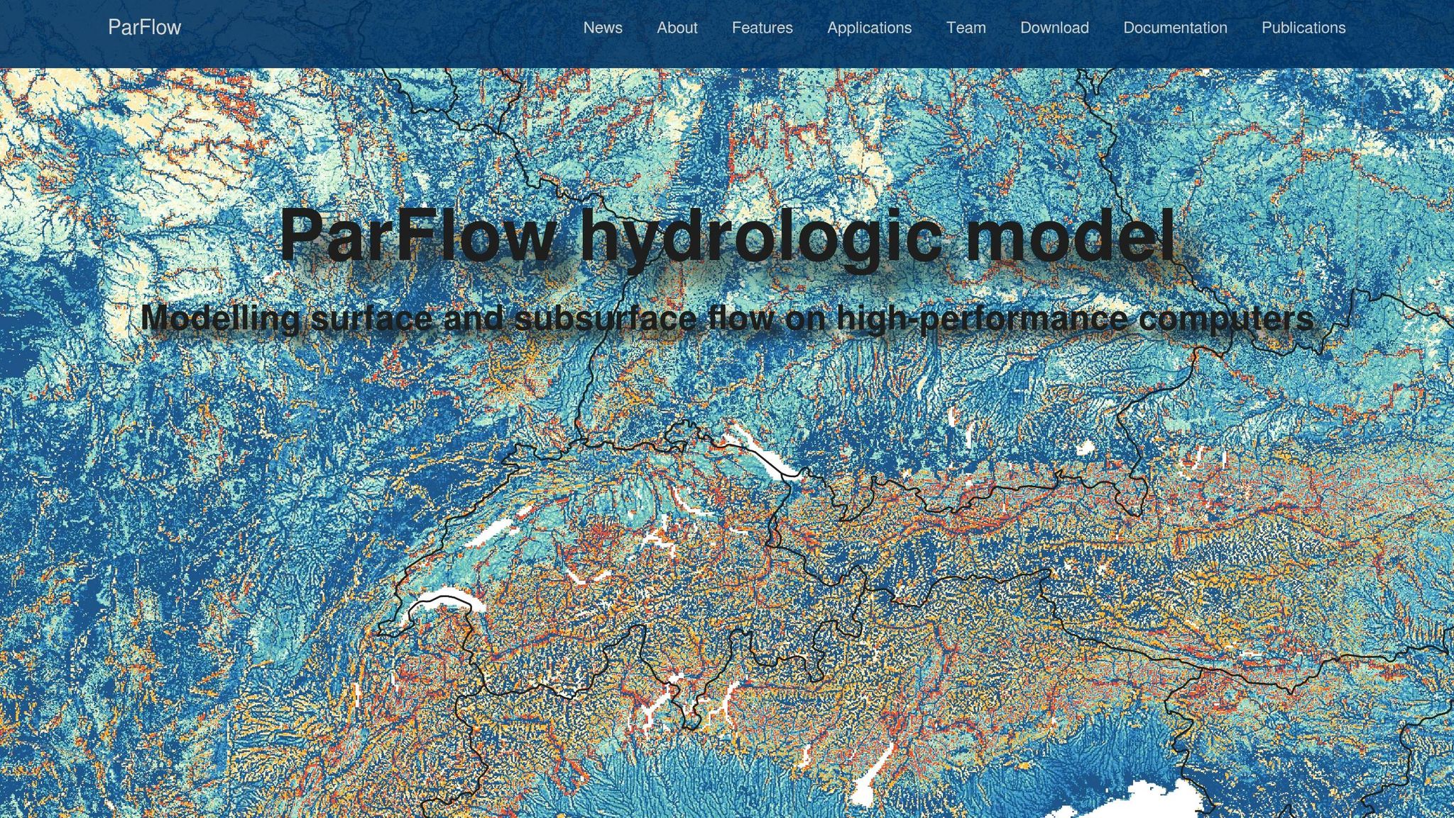
When stormwater projects involve high water tables, intricate soil layers, or steep terrain, HEC-HMS might fall short. That’s where ParFlow shines. This open-source tool models 3D groundwater flow alongside overland and channel flow, offering a comprehensive look at water movement.
In Maryland, ParFlow is particularly helpful for analyzing bioretention cells. For example, it can determine whether a cell will maintain unsaturated storage between storms or if the water table might rise and compromise performance. It’s also valuable for assessing whether repeated storms could elevate groundwater levels enough to impact nearby foundations or pavements. By representing Maryland’s mix of Coastal Plain sands, Piedmont clays, and other soil types in 3D, ParFlow provides insights that simpler models can’t.
However, ParFlow requires detailed soil data, advanced expertise, and significant computing power. As a result, it’s typically reserved for high-stakes projects or research, rather than routine subdivision designs.
GoldSim: Probabilistic Modeling for Long-Term Basin Performance

For long-term reliability, GoldSim offers a probabilistic approach that complements tools like HEC-HMS and ParFlow. Instead of focusing on specific storm events, GoldSim runs thousands of simulations using rainfall data that reflects Maryland’s climate patterns, including seasonal variability and storm types like Nor’easters and convective thunderstorms.
This makes GoldSim ideal for answering questions about long-term performance. For example: How often will a basin exceed its design capacity over 50 years? What’s the likelihood of back-to-back storms causing non-compliance with water quality requirements? By modeling storage elements, inflow, and outlet controls, GoldSim provides distributions for metrics like freeboard, overtopping frequency, and sediment accumulation.
While highly effective, GoldSim is a commercial platform best suited for larger firms, utilities, or agencies involved in strategic planning – not for small, individual projects.
R Hydrology Packages: Custom Data-Driven Workflows
R isn’t a standalone hydrological model, but its open-source programming environment includes a variety of hydrology-focused packages like hydroTSM, hydroGOF, and hydromad. These tools are invaluable for data wrangling, statistical analysis, and visualization.
In Maryland, R can automate the retrieval of USGS and NOAA data, streamline HEC-HMS input preparation, and facilitate performance comparisons through custom scripts. It’s also useful for pre-processing spatial data for ParFlow or analyzing large model outputs to align with Maryland’s regulatory standards.
While R offers unmatched flexibility and transparency, it does come with a steeper learning curve. Non-programmers may find it challenging, and custom scripts require validation to ensure accuracy.
SPARROW: Watershed-Scale Water Quality Context
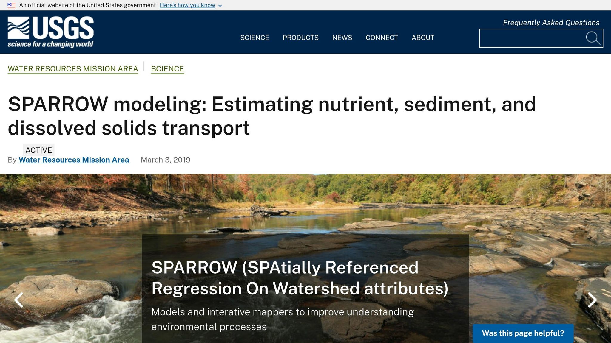
The SPARROW (SPAtially Referenced Regressions on Watershed Attributes) framework, developed by the USGS, connects watershed characteristics to long-term water quality. It’s particularly useful in Maryland for aligning stormwater designs with Chesapeake Bay TMDL goals.
For example, SPARROW can help determine how much a specific site contributes to regional nutrient loads and what reduction targets are necessary for compliance. While it doesn’t replace site-scale hydraulic models, it sets benchmarks for nutrient and sediment reductions that local controls must meet.
Comparison of Tools
| Tool | Best Fit | Key Limitation |
|---|---|---|
| HEC-HMS | Site- and small watershed-scale basin sizing | Limited groundwater and 2D hydraulics |
| ParFlow | Complex infiltration, high water tables, karst sites | Requires specialized expertise and data |
| GoldSim | Long-term reliability and overflow risk analysis | High cost; suited for larger agencies |
| R Packages | Data prep, calibration, and post-processing | Steeper learning curve for non-programmers |
| SPARROW | Watershed-scale nutrient and sediment load context | Not a site-scale hydraulic design tool |
Using Hydrological Tools in Maryland Residential Projects
Site Assessment and Feasibility Workflow
When applying hydrological modeling to a residential lot in Maryland, the process begins with on-site observations, ideally during or shortly after a rain event. This involves identifying flow paths, areas where water pools, signs of erosion, and gutter discharges. Additionally, note the size of roof areas, driveways, patios, and any indications that water might be reaching the foundation.
After gathering these observations, incorporate county GIS layers – focusing on floodplain boundaries and storm drain networks – and use the NRCS Web Soil Survey to determine the hydrologic soil groups (A through D). In central Maryland, most soils fall into Groups B through D, meaning runoff potential can vary significantly, even within a single neighborhood. To confirm whether the soil can support infiltration-based solutions or requires a daylight outlet, conduct an infiltration test at the site.
With this data, the next step is building a baseline model using tools like HEC-HMS or a county-provided spreadsheet, integrating NOAA Atlas 14 precipitation frequency data. For central Maryland, a 24-hour, 2-year storm typically brings about 3–3.5 inches of rainfall, while a 10-year storm delivers around 4.5–5 inches. Running the baseline model for these storm scenarios provides critical metrics like peak flow rates, total runoff volumes, and areas where water concentrates. These results guide the design process, particularly for landscaping solutions.
How Modeling Shapes Landscaping Design
Maryland’s strict stormwater standards require designs to address specific water management challenges. Using the data and baseline model, Pro Landscapes MD tailors solutions like grading adjustments, French drains, and dry riverbeds to meet these needs. For instance, if modeling shows that a 2-year storm causes water to pool in a side yard and reach the foundation quickly, the designer can test whether regrading to a 1–2% slope away from the house solves the issue or simply shifts the problem to a neighboring property. This insight prevents costly mistakes before any soil is moved.
French drain designs also benefit from modeling, which quantifies how much water needs to be intercepted and the soil’s capacity to absorb it. These findings influence decisions on trench length, depth, pipe diameter, and whether a daylight outlet or storm drain connection is necessary. This is especially important in Maryland, where clay-heavy soils often struggle to handle storm inflows through infiltration alone. Similarly, for dry riverbeds, modeling helps determine the required flow depth and velocity to ensure the feature can manage heavy stormwater effectively while also serving as an aesthetic landscape element.
"Drainage problems are complex and require a custom approach for each project… involving a detailed understanding of water flow, grading, and erosion control." – Pro Landscapes MD [1]
Every design decision – from patio placement to retaining wall grading and planting bed locations – is tied to water behavior on the site. Hydrological models ensure that finished grades, patio elevations, and swale alignments direct water toward infiltration features rather than structures or neighboring properties. This approach addresses Maryland’s stormwater challenges while creating functional and visually appealing landscapes [2].
Summary and Tool Selection Guidance
No single tool fits every scenario. Choosing the right one depends on the problem’s scope, the site’s complexity, and the expectations of Maryland regulators. For most residential lots, HEC-HMS is a reliable choice for event-based runoff analysis and permitting. On the other hand, R hydrology packages are ideal for creating custom, repeatable workflows, especially when incorporating NOAA rainfall data and NRCS curve numbers into sizing scripts. Both tools are free and align well with Maryland’s Environmental Site Design requirements.
Some tools cater to more specialized needs. ParFlow is particularly useful for sites with steep slopes, shallow bedrock, or high groundwater – common in areas like Frederick and Carroll Counties – where simpler methods might overlook important subsurface interactions. GoldSim is better suited for larger-scale or long-term analyses, such as assessing how a rain garden system performs under varying rainfall conditions over decades. Meanwhile, SPARROW doesn’t directly size individual practices but offers crucial watershed-level insights. This can help link a residential project to broader goals, like reducing nutrient loads in the Chesapeake Bay.
Here’s a quick-reference guide for Maryland residential scenarios:
| Tool | Best For | Typical User | Cost |
|---|---|---|---|
| HEC-HMS | Event runoff, drainage sizing, permitting | Civil engineers, landscape architects | Free |
| R hydrology packages | Custom, repeatable data workflows | Technical designers, consultants | Free (open-source) |
| ParFlow | Complex surface–subsurface interactions | Hydrologic/geotechnical engineers | Free (research-grade) |
| GoldSim | Long-term performance and risk analysis | Consultants, municipalities | Commercial license |
| SPARROW | Watershed nutrient and sediment context | Planners, watershed groups | Free (USGS) |
This comparison highlights which tool aligns best with specific project needs. Tailored hydrological modeling plays a central role in Maryland stormwater management. Using a model familiar to county reviewers can expedite the permitting process. For most homeowners and small-site designers, combining HEC-HMS with SPARROW context data is often sufficient to meet Environmental Site Design requirements and prepare a solid permit application.
Once modeling determines sizes, slopes, and flow paths, practical expertise comes into play. Pro Landscapes MD, a company specializing in drainage systems, French drains, permeable hardscapes, and grading solutions, can turn those model outputs into functional, buildable designs that perform effectively in the field.
FAQs
Which tool should I use for my Maryland stormwater project?
When tackling a stormwater project in Maryland, the best approach depends entirely on your property’s drainage requirements. Pro Landscapes MD provides a range of expert solutions tailored to these needs. These include French drains to redirect surface water, berms and swales to combat erosion, and advanced systems like bioretention basins, permeable pavement, and tree-box filters to handle heavy runoff while complying with local water quality regulations.
What Maryland data do I need before I start modeling?
Before diving into hydrological modeling in Maryland, take a close look at your site’s conditions. Pay special attention to clay-heavy soils, as these can significantly impact drainage and runoff patterns. Start with a thorough site survey to evaluate the layout, grading, and slope. This will help you pinpoint problem areas such as standing water or erosion. Additionally, make sure to check local environmental regulations to ensure your modeling and stormwater management strategies meet legal standards.
How can I ensure my model meets MDE review requirements?
To satisfy the Maryland Department of the Environment (MDE) review requirements, your hydrological model must adhere to water quality standards and runoff regulations. When designing drainage systems, take into account critical factors such as the size of the site, its topography, and the soil conditions. Bringing in a professional to assess your model can ensure it meets local stormwater management and erosion control mandates, helping you achieve both compliance and reliable performance.
Chat with Us