









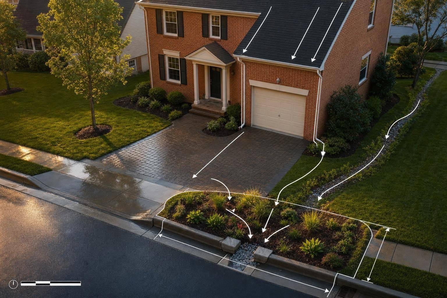
- bhavya gada
- No Comments
If a Maryland residential stormwater model misses runoff area, storage, or overflow routing, the plan can fail review. I’d boil this article down to one point: the model has to show where water comes from, how much must be stored, and where it goes during small and large storms.
If you own, design, or review a residential project in Maryland, these are the main checks I’d watch first:
- Runoff inputs: drainage area, impervious cover, soil group, curve number, and time of concentration
- Sizing targets: WQv, Rev, Cpv, plus 2-year, 10-year, and 100-year storm checks
- Design approach: use ESD to the MEP first, with lot-level practices like rooftop disconnection, rain gardens, swales, and micro-bioretention
- Hydraulic review: pipes, swales, stage-storage, stage-discharge, freeboard, and overflow paths
- Plan review items: drainage maps, pre/post runoff numbers, storage tables, outlet math, and matching plan dimensions
- Field fit: built grades, inverts, ponding depth, and overflow elevations must match the approved model
A few numbers matter right away. The article points to the 1-year, 24-hour storm for Cpv, a 12 to 24 hour release window for channel protection, 24 hours as a common lawn ponding limit, 48 hours for some swales, and about 0.5 to 1.0 foot of freeboard on small practices in many county reviews.
In plain English, I see the article as a guide to three linked questions:
- How much runoff will the lot make?
- How much of that runoff must be stored or soaked in?
- Can the site move overflow away from the house and into an approved outlet?
Here’s the short version: Maryland stormwater modeling for residential work is less about fancy software and more about clean inputs, correct storage math, and clear flow paths. If those three parts line up, plan review tends to go much smoother.
Maryland Design Standards That Shape the Model
Maryland’s Stormwater Design Manual turns broad rules into four day-to-day sizing checks: WQv, Rev, Cpv, and larger-storm conveyance. The state frames stormwater design around five main goals: water quality, recharge, channel protection, overbank flood control, and extreme flood protection [8][11][16].
For things like rooftops, driveways, swales, and rain gardens, those standards set the storage and discharge limits a design has to meet. Put simply, they tell the model how much runoff needs to be captured, stored, and released without causing problems downstream.
Key Sizing Targets: WQv, Rev, Cpv, and Larger Storm Checks
These four sizing targets drive most of the math in a residential stormwater model.
Water Quality Volume (WQv) is the runoff volume from a small, frequent storm that must be captured and treated for pollutant removal. Maryland calculates it as WQv = (P × Rv × A) / 12, where P is the design rainfall depth, Rv = 0.05 + 0.009I based on percent impervious cover, and A is the drainage area in acres [8][11][12]. The result is a storage requirement in cubic feet for a rain garden, micro-bioretention cell, or small pond.
Recharge Volume (Rev) is the share of runoff that must soak into the ground to help maintain groundwater recharge. Rev is based on soil recharge factors and Maryland’s average annual rainfall [8][10]. If an upstream infiltration practice already provides documented Rev, that volume can sometimes be taken out of the downstream WQv sizing need, which can shrink later facilities.
Channel Protection Volume (Cpv) focuses on stream channel stability. It requires runoff from the 1-year, 24-hour storm to be captured and released slowly, usually over 12 to 24 hours, so downstream channels are not hit with erosive peak flows [4][8][9]. In the model, that means setting the outlet to release the 1-year, 24-hour inflow over 12 to 24 hours and checking that the peak discharge drops as required. Those storage and release checks feed straight into runoff inputs and flow routing.
For larger storms, designers check the 2-year, 10-year, and 100-year events to confirm that post-development peak flows do not exceed pre-development levels at key discharge points [11][18]. Pipes, swales, and emergency overflow paths also have to show enough capacity and freeboard for those storms.
| Sizing Target | Design Storm | Primary Model Output |
|---|---|---|
| WQv | Water quality storm | Storage volume (cubic feet) |
| Rev | Soil-based fraction of WQv | Infiltrated volume (cubic feet) |
| Cpv | 1-year, 24-hour storm | Extended detention storage + release rate |
| Overbank / Extreme Flood | 2-year, 10-year, 100-year storms | Peak discharge (cfs), conveyance capacity |
How ESD to the MEP Changes Residential Design Strategy
Maryland law requires Environmental Site Design to the Maximum Extent Practicable (ESD to the MEP) before a designer can lean on larger structural facilities [14][15]. In practice, the model should start with small, spread-out practices placed close to where runoff begins. That usually means:
- rooftop disconnection
- sheet flow to conservation areas
- rain gardens
- micro-bioretention
- swales
This approach cuts runoff volume and lowers the storage the model has to handle. Instead of pushing everything into one large facility, the design spreads the work across several smaller practices around the lot.
State rules also require ESD practices to maintain 100% of the average annual pre-development groundwater recharge volume where practicable, so the model has to show volume reduction, not just lower peak flow rates [15][20]. When ESD practices together meet the Target ESD volume (ESDv), many counties allow Rev credit if the practices document the required recharge volume, which can make the modeling paperwork easier [13].
How County Review Standards Affect Plan Submittals
The state manual sets the base rules, but counties apply them through their own codes, checklists, and review habits. Local review checklists often ask for impervious-area calculations, drainage-area maps, ESD sizing sheets, and storm-event summary tables [1][17][19].
That matters more than it might seem. If you know which county checklist applies before you build the model, you can avoid a lot of back-and-forth during plan review. Those review items tie directly to the same runoff inputs, storage sizes, and routing checks covered next.
sbb-itb-843f8be
Model Basics: Runoff Inputs, Storage Sizing, and Flow Routing
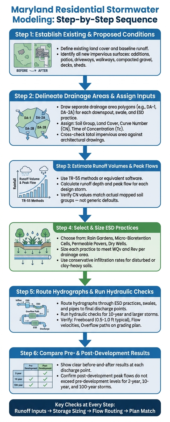
Maryland Residential Stormwater Modeling: Step-by-Step Process
Every stormwater model for a Maryland residential lot starts with the same raw material: site data. From there, the process is pretty direct: turn that data into runoff numbers, use those numbers to size storage, and then test routing and overflow. When you see how those parts fit together, it becomes much easier to follow a designer’s logic – and spot trouble before it shows up on a plan.
Hydrologic Inputs That Control Runoff Rates and Volumes
The first thing a model needs is a drainage area. That’s a polygon drawn around each surface that drains toward a certain inlet, swale, or rain garden. Each drainage area should be delineated separately by outfall or practice. A small miss here – like leaving out a shed roof or undercounting a driveway – can change the storage size by more than you’d think.
Next comes the runoff curve number (CN). This number estimates how much rainfall turns into runoff based on soil type and land cover. Higher CN values on less permeable or more impervious sites mean more runoff volume and more storage demand.
The third key input is time of concentration (Tc). Tc is the travel time from the farthest point in the drainage area to the outlet. When Tc is shorter, peak flow goes up.
Then the model runs the required design storms to calculate runoff depths and peak flows for each sizing check. For a simple lot, spreadsheet methods may be enough. For a design with more than one practice or a shared facility, routed hydrographs are usually the better fit.
Reviewers look closely at drainage area, CN, and Tc when checking WQv, Rev, Cpv, and overflow capacity. Those inputs feed the storage and routing checks that decide whether the design passes.
Hydraulic Checks for Pipes, Swales, Rain Gardens, and Overflow Paths
Hydrology tells you how much runoff you have. Hydraulics tells you whether the system can move it, store it, and release it safely. Once runoff is known, the model checks whether each practice and conveyance path can handle the flow. The main review question is simple: does water move away from the house and into approved conveyance?
For pipes, the main check is whether the pipe can carry the chosen design storm – often the 10-year event – without surcharging. Designers use Manning’s equation or software to confirm that slope, diameter, and inlet/outlet control are adequate [21].
For swales, the checks focus on slope, velocity, storm capacity, and freeboard [22]. Montgomery County also requires 0.5 ft of freeboard for yard swales and culverts during the 10-year storm [21].
For rain gardens and micro-bioretention, the hydraulic review centers on two curves: stage-storage and stage-discharge. The stage-storage curve shows how much volume is stored at each water surface elevation, including surface ponding, soil media voids, and any gravel layer below. The stage-discharge curve shows how fast water leaves through a perforated underdrain, small orifice, or overflow weir at different depths. Together, these curves let the model check filling, drainage, and overflow across more than one storm size.
Overflow path verification is where a lot of residential designs get shaky. Montgomery County requires drainage away from foundations and limits lawn ponding to 24 hours, while swales may drain for up to 48 hours [2]. Every overflow route should be traced on the grading plan and checked against the model output to make sure water heads toward streets, swales, or designated easements – not toward foundations, window wells, or lower neighboring yards.
Step-by-Step Modeling Sequence for a Residential Lot
Use the same inputs in the same order: existing conditions, proposed conditions, runoff, practice sizing, routing, then review.
- Establish existing and proposed conditions Define the existing land cover and run hydrology for all required design storms to set the baseline runoff response. Then identify each new or changed impervious surface, such as additions, patios, driveways, and walkways. This step often catches missed impervious area, including compacted gravel areas, decks, or sheds.
- Delineate drainage areas and assign inputs Draw separate drainage area polygons for each downspout, swale, and proposed ESD practice. Assign soil group, land cover, CN, and Tc to each sub-area. Cross-check the total modeled impervious area against the architectural drawings so discrepancies show up before calculations are run.
- Estimate runoff volumes and peak flows Use TR-55 methods or equivalent software to calculate runoff depth and peak flow for each design storm. Check that CN values match actual mapped soil groups – not generic defaults – especially in areas with tight clays common across Baltimore County and parts of Montgomery County.
- Select and size ESD practices Choose rain gardens, micro-bioretention cells, permeable pavers, or dry wells. Size ESD practices to meet WQv and Rev for each drainage area. Be conservative with local soil infiltration rates, since disturbed or clay-heavy soils can drain much more slowly than expected.
- Route hydrographs and run hydraulic checks Build the routing model to send hydrographs from each sub-area through ESD practices, swales, and pipes to final discharge points. Run hydraulic checks on all conveyance features for the 10-year storm and larger storms. Verify freeboard, flow velocities, and overflow paths on the grading plan.
- Compare pre- and post-development results The finished model should show clear before-and-after results at each discharge point.
What Reviewers Check During Maryland Plan Review
Once the model is built, reviewers check whether the plan, calculations, and site drainage line up with Maryland standards. Under Maryland law, stormwater management approval has to happen before a grading permit or building permit can be issued.[23] That means plan review is a permit gate, not just a paperwork step.
Reviewers use the model to verify storage, routing, and discharge before they sign off. For projects that disturb at least 5,000 square feet, Maryland guidance uses a phased review process: concept, site development, and final stormwater management plan.[8][26] You can’t move to the next phase until comments from the approving authority are addressed.[27][28]
The review package needs to show one clear story: the modeled runoff, storage, and flow paths must match the submitted site plan.
Required Model Outputs and Supporting Documents
Reviewers want one package with the maps, calculations, and backup documents tied together. A complete submittal usually includes:
- Drainage area maps with clear IDs like DA-1 and DA-2A, used the same way throughout the calculations
- Pre- and post-development land cover breakdowns with curve numbers and hydrologic soil groups
- Storm event calculations for WQv, Rev, Cpv, and larger storm checks
- Stage-storage tables tied to actual plan elevations
- Outlet and weir calculations
- Conveyance capacity checks for pipes and swales
- A short narrative that connects the results to ESD-to-the-MEP requirements
Reviewers compare the package line by line. They check that acreage, soil groups, and practice dimensions match everywhere they appear. Even a small acreage mismatch on a residential lot can lead to a review comment.
Common Review Issues with Runoff, Storage, and Flow Paths
When residential stormwater plans come back for revision, the same trouble spots show up again and again.
- Missing drainage area. Roof downspouts, off-site runoff, or driveway sections draining to a practice are left out of the model. That usually makes the practice look smaller than it needs to be.
- Wrong soil group. If the model uses a soil group that infiltrates more than county maps, test pits, or geotechnical reports support, infiltration gets overstated and storage gets understated.
- Storage measured to the wrong elevation. Using the top of berm or mulch surface instead of the planned ponding depth can make storage capacity look bigger than it is.
- Missing overflow or freeboard. Reviewers often flag discharge points that sit too close to foundations and lack energy dissipation. For small practices, counties commonly expect about 0.5 to 1.0 foot of freeboard. Any outfall daylighting near a structure without an apron or level spreader is a common reason for revision.
Comparison Table: Model Categories and Their Review Checks
The table below shows how reviewers split hydrologic, hydraulic, and compliance checks.
| Model Category | Main Inputs | Key Outputs | Typical Review Check |
|---|---|---|---|
| Hydrologic modeling | Drainage area, CN, Tc, design storms | Runoff depth, peak flow, runoff volume | DA acreage matches plans; CN and soil groups match supporting data; Tc follows Maryland manual methodology |
| Hydraulic modeling | Stage-storage curves, outlet geometry, pipe/swale dimensions | Water surface elevations, discharge rates, drawdown time | Freeboard verified; drawdown meets required time; pipe and swale capacity checked for design storm |
| Compliance review | Pre/post peak flows, WQv/Rev provided vs. required, overflow paths | Peak flow comparison table, volume compliance summary | Pre- and post-development peaks compared at each discharge point; required vs. provided WQv/Rev shown clearly |
County checklists can go past what the statewide manual asks for. Some jurisdictions also want signed and sealed plan sets, written responses to each reviewer comment, and redlined documentation.[25]
Applying the Model to Residential Drainage Work in Central Maryland
After review, the main issue is pretty simple: does the drainage system in the yard match the approved model?
How Drainage Design Choices Affect Compliance and Long-Term Performance
Built grades, inverts, and slopes need to match the approved model. This is often where problems start. The model assumes water will move from roofs, driveways, and patios toward specific practices at set slopes.[24][7][1] When finished grades shift from plan, runoff can collect near the foundation or put too much water into smaller practices. Vegetated flow paths should generally stay at or below 5%.[30]
French drains also have to match the modeled trench depth, invert, and void storage. If they don’t, they won’t perform as planned.[24][5] The same goes for dry riverbeds. They need to be built at the modeled crest elevation so storage and overflow control still work the way the model assumed.[24][5]
Rain gardens need the planned surface area, ponding depth, and drawdown time. If excavation is too shallow or the media changes, storage drops and the chance of overtopping goes up.[24][6][29]
Environmental pavers rely on base-course void space for their modeled WQv and Rev storage. So if the base is thinner than planned, storage capacity drops too, and surface overflow can start sooner than the model allowed.[24][7][5]
In plain terms, even a sound model can fall apart in the field if the install is off.
Working with Local Professionals on Maryland Stormwater Projects
Local crews can help bridge the gap between approved plans and what conditions look like on site. In central Maryland, county ordinances add local rules on top of MDE’s ESD-to-MEP framework. That means residential drainage work has to meet both state and county standards.[31][32][3][1]
Pro Landscapes MD serves central Maryland and helps align drainage installation with approved stormwater plans.
Key Model Checks Every Residential Project Should Meet
The same core checks still matter: runoff inputs, storage sizing, and flow routing all need to match what gets built. That means checking built slopes, inverts, ponding depths, and overflow elevations against the approved model.[24][7][1] A residential project passes only when the built system matches the approved model at every key elevation and flow path.[24][4][5]
FAQs
When is a simple spreadsheet enough for stormwater modeling?
A simple spreadsheet is often enough for basic stormwater modeling during early site reviews or plain runoff estimates on smaller, less complex residential jobs.
In Maryland, though, that’s usually just the starting point. Most development projects need detailed calculations and must meet Environmental Site Design (ESD) rules and Maryland Department of the Environment standards.
What usually causes a Maryland residential stormwater plan to fail review?
Most review failures come down to submission errors.
That usually means the plan is incomplete, key calculations are missing, required documents weren’t included, or some items weren’t sent within the required time window.
Plans also get rejected when required agency approvals aren’t in place first. And even if the paperwork is there, a plan can still fail if it doesn’t meet state and local standards for runoff control, grading, or required ESD practices.
How do I confirm the built drainage work matches the approved model?
Conduct regular site inspections and document the results to show compliance with Maryland standards. Check that flow paths, inlets, and drainage features line up with the approved site map and match the drainage patterns shown in your stormwater management and sediment control plans.
Routine maintenance matters too. Clear blockages, remove sediment buildup, and keep the system working the way it was designed to work. Local regulators, including the Maryland Department of the Environment, may also inspect the site to confirm permit compliance.
Chat with Us