


- bhavya gada
- No Comments
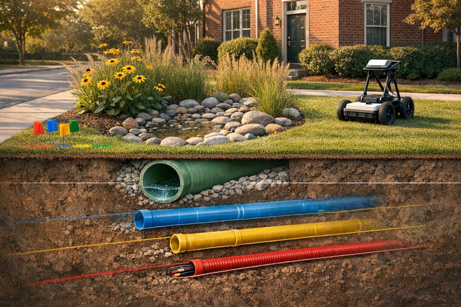
Utility mapping is essential for any Maryland landscaping or stormwater project involving excavation. It helps identify underground utilities like water lines, sewer pipes, and gas lines, preventing costly damage and ensuring safety. Maryland’s older neighborhoods and unique soil conditions make accurate mapping even more critical. Here’s a quick breakdown of the four main methods:
- Records Research & GIS: Uses existing maps and data to create an initial utility overview. It’s cost-effective but less precise, especially in older areas with incomplete records.
- Electromagnetic (EM) Locating: Identifies metallic utilities like gas or water lines. Affordable and effective but struggles with non-metallic pipes.
- Ground Penetrating Radar (GPR): Detects both metallic and non-metallic utilities, offering higher accuracy. However, it’s less effective in clay-heavy soils and costs more.
- Test Holes & Vacuum Excavation: Physically exposes utilities for unmatched precision. Best for critical areas but comes with higher costs and requires careful planning.
For smaller projects, basic methods like records research and EM locating may suffice. For larger or complex projects, combining methods ensures better accuracy and avoids unexpected issues. Maryland’s diverse landscapes and strict stormwater regulations make proper utility mapping a smart investment for any homeowner or contractor.
How to Find Underground Utilities (U.S. Method – Including Private Lines 811 Won’t Mark)
1. Records Research and GIS-Based Utility Mapping
Before heading to the site, gather all available utility records – such as as-built drawings, utility maps, subdivision plats, and Miss Utility responses – and combine them into a digitally georeferenced map. This creates a comprehensive view of what might lie underground, tied to property boundaries and stormwater features.
Accuracy
According to ASCE 38-22, this records-based approach (QL-D/QL-C) provides horizontal accuracy within a range of a few feet or more, but depth data is often unreliable. As ASCE 38-22 points out:
"often unreliable"
This has historically resulted in utility conflicts and expensive change orders. While this level of confidence works for early planning and layout decisions, it’s crucial to verify critical locations on-site.
Cost
Records research is the most budget-friendly method, primarily requiring staff time. Many Maryland counties, including Howard, Montgomery, and Frederick, offer public GIS layers for free or at minimal cost. These layers include data on storm drains, stormwater facilities, parcels, floodplains, and soils. Compared to vacuum excavation or large-area GPR surveys, this approach represents a small fraction of the total investigation budget while covering the entire site. That makes it the logical first step for any project.
Applicability to Maryland Landscapes
Older neighborhoods often have multiple layers of utility work, including undocumented repairs, while newer subdivisions tend to have more reliable as-builts that integrate seamlessly into county GIS systems. However, jurisdictional complexities can pose challenges, as state highways, county roads, municipal utilities, and private HOA infrastructure often maintain separate records. In tidal and coastal areas, storm drain outfalls and tide-influenced infrastructure require additional scrutiny during the records review process. These factors highlight the importance of early utility mapping to guide stormwater design decisions.
Impact on Stormwater Design
For stormwater projects in Maryland, early GIS mapping helps identify no-go zones and avoid onsite conflicts. By overlaying proposed grading and BMP (Best Management Practice) locations with known utility alignments, designers can adjust plans – shifting rain gardens away from sewer easements or placing permeable paver bays over deeper storm drain laterals – before diving into detailed engineering. Maryland’s Environmental Site Design (ESD) standards encourage small-scale, distributed practices in tight spaces, making early conflict screening a critical step. Missing utility conflicts early on can increase project costs by 5–10%, which is why this upfront mapping process is well worth the effort.
2. Surface Marking and Electromagnetic Locating
After completing the records research, the next step is heading to the site to trace what’s actually underground. Surface marking with electromagnetic (EM) locating allows technicians to identify buried utilities without digging. Using a transmitter and receiver, they send or detect signals on conductive utilities – such as metallic pipes, copper water lines, gas lines with tracer wires, and buried cables. Once located, these utilities are marked on the surface using paint or flags, adhering to APWA color codes: red for electric, yellow for gas, blue for water, green for sewer, and orange for communication.
In Maryland, this process starts with a mandatory call to 811/Miss Utility. Public utilities are marked within a specific timeframe, typically about 12 business days, after which markings must be refreshed. This is particularly important for phased projects, like landscaping or stormwater work, where construction spans several weeks.
Accuracy
EM locating is most effective for metallic utilities, offering a horizontal accuracy of 6–12 inches, though designers typically account for a 1–2 foot tolerance. Depth estimates, however, come with a ±10–15% margin of error, which can increase in congested or deeper areas. The main challenge lies in identifying non-metallic pipes – like PVC, HDPE, or older concrete types – unless they’re equipped with tracer wires or sondes. In Maryland’s older neighborhoods, undocumented plastic service lines are common, posing a significant detection issue.
Cost
In the Mid-Atlantic, private EM locating services generally cost $125–$250 per hour, or a few hundred dollars per visit for a standard residential property. This is a small price to pay compared to the potential expense of hitting a buried gas or electric line during construction. For drainage work or regrading, private EM locating is a critical step in pre-construction planning, especially for identifying irrigation lines, low-voltage lighting, and private laterals that aren’t covered by 811.
Applicability to Maryland Landscapes
EM locating proves effective across Maryland’s diverse geology. From the clay-rich Piedmont soils in Howard, Carroll, and Frederick counties to the sandy coastal plain soils in Anne Arundel and Prince George’s counties, the method works consistently because it relies on the conductivity of the utility, not the soil type. However, there are challenges. Crowded suburban areas can create overlapping signals, and steep or heavily wooded lots – like those in Ellicott City or Sykesville – can make access difficult. In such cases, combining EM locating with records research or ground penetrating radar is often the best approach, especially when non-metallic lines are suspected.
Impact on Stormwater Design
Accurate surface markings are crucial for determining where stormwater features can be placed. Knowing the exact location of buried utilities ensures designers can maintain safe clearance distances when installing bioretention cells, routing French drains, or excavating for permeable paver bases. These markings also help identify areas where hand-digging or vacuum excavation is needed before heavy equipment is used – protecting both workers and the project timeline. The next section will delve into how ground penetrating radar can further improve utility detection on Maryland sites.
3. Ground Penetrating Radar (GPR)
GPR builds on electromagnetic (EM) locating by addressing its shortcomings, especially when it comes to identifying non-metallic utilities in complex underground conditions. This technology works by sending electromagnetic waves into the ground and analyzing the return signals to create a continuous subsurface profile, known as a radargram. A trained technician interprets this radargram to locate utilities and determine their depths. Unlike EM locating, GPR can detect both metallic and non-metallic utilities, making it a go-to method for identifying PVC, HDPE, and concrete infrastructure that EM methods might miss.
Accuracy
GPR provides horizontal accuracy within a few inches and depth estimates within 10–15% of the actual depth. However, its effectiveness depends on soil conditions. In dry, sandy soils, signals can penetrate as deep as 10–15 feet, while wet, clay-rich soils reduce that range to 3–6 feet. Antenna frequency also plays a role: lower frequencies (250–400 MHz) are better for detecting deeper targets, while higher frequencies (900–1,600 MHz) offer sharper resolution for shallow utilities. Since results rely on interpretation, having a skilled technician is crucial, and critical findings should always be verified with test holes before excavation begins.
Cost
GPR surveys generally cost between $150 and $300 per hour or $1,000 to $2,000 per day, depending on the equipment, technician expertise, and project complexity. For smaller areas, some providers offer flat-rate packages ranging from $800 to $2,500. Studies show that combining GPR with other methods like records research and EM locating can reduce utility-related change orders by 30–50%, often offsetting the initial cost of the survey.
Applicability to Maryland Landscapes
The success of GPR varies with soil conditions, which differ across Maryland. In sandy Coastal Plain soils, such as those in Anne Arundel and Prince George’s counties, GPR performs well, providing reliable utility mapping. However, in clay-rich Piedmont soils found in Baltimore, Howard, and Montgomery counties, the increased moisture and conductivity limit the signal’s depth and clarity. Urban areas like Baltimore and Washington, DC, where layered development and incomplete records are common, greatly benefit from GPR’s capabilities. In areas with dense clay or high water tables, GPR is most effective when paired with methods like EM locating and selective test holes. Across Maryland’s diverse landscapes, GPR plays a vital role in achieving accurate utility mapping.
Impact on Stormwater Design
GPR offers stormwater designers a detailed view of underground conditions before excavation begins. It can identify existing storm drains, culverts, underdrains, and outfalls that might interfere with planned bioretention cells, French drains, or permeable paver installations. It also detects buried voids, old foundations, and rubble that could hinder infiltration or necessitate over-excavation. For Maryland projects adhering to MDE stormwater regulations and local requirements, this underground insight ensures proper separation from water, sewer, or gas lines, helping designers avoid costly mid-construction changes. Teams like Pro Landscapes MD, working on drainage and hardscaping projects in Howard, Montgomery, and Baltimore counties, rely on this pre-construction information to refine designs and ensure compliance with the state’s stringent stormwater standards.
sbb-itb-843f8be
4. Test Holes and Vacuum Excavation
When records, surface markings, and ground-penetrating radar (GPR) leave questions unanswered, test holes and vacuum excavation offer a more direct way to verify utilities. These methods go beyond estimation, physically exposing pipes or conduits to confirm their exact location, size, material, and condition. A test hole – also known as potholing or daylighting – involves a small, targeted excavation to expose buried utilities. On the other hand, vacuum excavation, or soft digging, uses pressurized air or water to loosen the soil, which is then removed with a vacuum hose. This approach minimizes the risk of damaging the utility while providing accurate information.
Accuracy
Test holes deliver unmatched precision, with measurements accurate to within an inch. They provide critical details like material type, condition, diameter, and trench configuration – details that indirect methods can only estimate. For engineers and contractors, this level of accuracy is crucial when finalizing construction plans, such as staking or setting elevations for stormwater structures. By confirming these details, test holes eliminate guesswork and ensure that designs align with the actual site conditions.
Cost
The cost of test holes depends on several factors, including mobilization, the number of holes required, site accessibility, and soil conditions. For example, dense Piedmont clays may take longer to excavate than loose coastal sands, and urban settings might require additional expenses like traffic control. To manage costs, it’s wise to prioritize test holes at critical points – such as where a storm drain crosses a gas line or where a retaining wall footing is near an unknown utility. Grouping test holes in the same area and scheduling them early in the design phase can also help reduce setup times and avoid costly surprises during construction.
Applicability to Maryland Landscapes
Vacuum excavation works well across Maryland’s diverse geology. In loose coastal plain soils, the process is quick and efficient, while denser soils require adjustments in pressure and timing. Rocky or gravelly conditions may call for a combination of vacuum excavation and light mechanical chipping to minimize disruption. In urban areas, the small footprint of vacuum excavation causes less disturbance to pavement and traffic compared to traditional trenching methods. Similarly, in suburban neighborhoods like Columbia, Ellicott City, or Gaithersburg, careful backfilling and restoration protect lawns, plantings, and hardscaping. Contractors such as Pro Landscapes MD, which specialize in both drainage and hardscaping, can seamlessly integrate test-hole verification with final grading and landscape restoration, leaving the site clean and intact.
Impact on Stormwater Design
Test holes play a key role in ensuring precise stormwater design. Maryland’s stormwater systems – such as bioretention cells, permeable pavers, French drains, rain gardens, and underground detention systems – depend on accurate elevation control to function properly and meet regulations. Even small discrepancies in utility elevations can disrupt underdrain designs or force changes to outlet configurations. By confirming the actual inverts of utilities, test holes allow designers to confidently set inlet and outlet elevations. They also confirm clearances between proposed stormwater management practices (BMPs) and existing utilities like water, gas, or fiber, ensuring proper separation distances. In retrofit projects, especially in older neighborhoods where utility maps are often unreliable, this physical verification can prevent costly delays and field adjustments, smoothing the path to regulatory approval.
Pros and Cons
4 Utility Mapping Methods for Maryland Landscapes: Cost, Accuracy & Best Use
Utility mapping methods for Maryland projects offer a range of benefits and challenges, depending on factors like project complexity, budget, and risk level. Below, you’ll find a breakdown of these methods, along with a summary table to help guide your decision-making process.
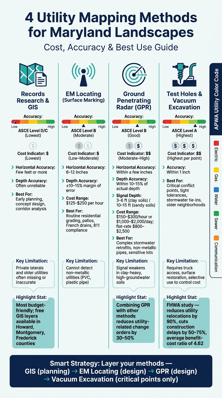
Here’s how the four common methods compare based on key criteria for Maryland projects:
| Method | Accuracy (ASCE 38 Level) | Relative Cost | Best Fit for Maryland Projects | Key Limitation |
|---|---|---|---|---|
| Records Research & GIS | Lowest (Level D/C) | $ Lowest | Early planning, concept design, corridor analysis | Private laterals and older utilities often missing or inaccurate |
| EM Locating (Surface Marking) | Moderate (Level B) | $ Low–Moderate | Routine residential grading, patios, French drains, 811 compliance | Cannot detect non-metallic utilities (e.g., PVC storm drains, plastic pipe) |
| Ground Penetrating Radar (GPR) | Good (Level B) | $ Moderate–High | Complex stormwater retrofits, sites with non-metallic pipes, sensitive lots | Signal weakens in clay-heavy, high-groundwater soils |
| Test Holes & Vacuum Excavation | Highest (Level A) | $ Highest per point | Critical conflict points, tight tolerances, stormwater tie-ins, older neighborhoods | Requires truck access, surface restoration, and selective use to control cost |
Records Research & GIS: This method is a quick and inexpensive way to start, making it ideal for early planning stages or corridor analysis. However, it often lacks accuracy in older neighborhoods where utility records may be incomplete or outdated. Treat this data as preliminary and supplement it with more precise methods as needed.
EM Locating (Surface Marking): This approach is effective for identifying metallic utilities and complies with the 811 process. It’s suitable for routine residential projects like patios or grading. However, it struggles to detect non-metallic utilities unless tracer wires are present, limiting its usefulness for certain stormwater projects.
Ground Penetrating Radar (GPR): GPR is a versatile option for detecting both metallic and non-metallic utilities. It’s particularly useful for complex stormwater retrofits or sensitive sites. That said, it comes at a higher cost and is less effective in clay-heavy soils or areas with high groundwater, where the signal weakens. Skilled operation is crucial to get the most out of this method.
A Federal Highway Administration (FHWA) study on Subsurface Utility Engineering (SUE) found that using comprehensive utility investigations – including vacuum excavation test holes – reduced utility relocations by 90%, cut construction delays by 50–75%, and delivered an average benefit–cost ratio of 4.62, with a range of 3:1 to 10:1.
Test Holes & Vacuum Excavation: This method offers the highest accuracy (Level A), making it indispensable for critical conflict points or projects with tight tolerances, like stormwater tie-ins. While it’s the most expensive per location due to the need for truck access and surface restoration, its targeted use at high-risk points can be the most cost-effective approach. For Maryland stormwater projects, where precision in pipe elevations is crucial to bioretention designs, this method often proves invaluable.
Conclusion
There’s no one-size-fits-all solution when it comes to mapping methods for Maryland projects – it all depends on the type of project, its location, and the level of risk involved.
For smaller residential projects – like adding a patio, reshaping a yard, or building a shallow swale – an 811 call, combined with records research and electromagnetic (EM) locating, is often enough. This approach is quick, cost-effective, and meets compliance standards. But if your property has non-metallic pipes, aging infrastructure, or incomplete utility records, you might not uncover everything you need to know.
On the other hand, larger projects with significant stormwater needs – such as installing French drains, bioretention cells, box-and-pipe systems, or working near home foundations – require a more precise approach. Factors like clay-heavy soils, high water tables, and mixed-age infrastructure can lead to unexpected underground challenges. For these scenarios, using ground-penetrating radar (GPR) or vacuum excavation at key points can save you from costly surprises.
As one professional points out:
"Drainage problems are complex and require a custom approach for each project. These issues can cause long-term damage to your property if not handled correctly." – Pro Landscapes
A smart approach for most Maryland residential stormwater projects is to layer your methods by project phase. Start with GIS and records research during the planning stage, move on to EM locating and GPR in the design phase, and save vacuum excavation for critical areas where connections or crossings are necessary. This phased method not only improves safety but also keeps costs manageable and helps avoid unexpected delays or mid-construction issues. For Maryland homeowners, Pro Landscapes MD offers free estimates for drainage and landscaping projects, making it easier to get started.
FAQs
Do I need GPR if I already called 811?
When you call 811, it helps identify public utility lines, but it doesn’t cover private lines on your property. For excavation projects like installing French drains or grading, using Ground Penetrating Radar (GPR) can provide an additional level of safety. In Maryland, where soil conditions and landscapes vary, GPR is especially useful for spotting unmarked lines. This not only safeguards your property but also helps ensure your drainage installation goes smoothly.
What is the best utility-mapping method for Maryland’s clay soils?
Permeable paver systems work especially well in Maryland’s clay-heavy soils. They help manage stormwater by letting rainwater soak into the ground, which cuts down on runoff, flooding, and erosion. While smaller projects might seem doable for DIY enthusiasts, the challenges of clay soil often call for professional installation to ensure the base is prepared correctly and the system holds up over time.
When are test holes or vacuum excavation worth the cost?
Test holes and vacuum excavation play a crucial role in intricate drainage or underground construction projects, like setting up box or pipe drain systems. These techniques allow for precise identification of underground utilities, minimizing the risk of accidental damage during digging. They also provide insight into soil conditions and water flow patterns. This information helps Pro Landscapes MD design customized drainage systems that protect your home’s foundation and property from potential water damage over time.
Chat with Us